...it strikes me that the use of the half-mile boundary of a TOD is actually a bad one. Calthorpe specifies not a distance, but a 10 minute walk. The half-mile standard comes from assuming that people walk 3 miles per hour, hence a half mile in 10 minutes. However, that represents an unimpeded distance, without having to wait to cross roads.
The reality is more prosaic: an impeded 10 minute minute walk might only take you 2/3 as far. And indeed, when Calthorpe gives a number, he suggests 3/8ths of a mile (600m/1980').
And of course, distance from the transit station varies by rather much by the street network. Jarrett Walker of Human Transit describes it well, so I won't belabor the point.
Cities delineating a TOD might do better to use a '10 minute walk' standard, measuring linear distance along public right of ways, and demanding frontage on such a right of way.
Wednesday, November 28, 2018
Wednesday, October 24, 2018
Is urban water distribution a natural monopoly?
Arguably, for water, it's a natural monopoly. Public streets typically provide easements for both water and sewer. Both leak, especially with age. So there is a clear need to separate them, so cities put water lines on one side, and sewer lines on the other. Water lines have to be buried below the local frost line, so a second set would need to be even deeper, and provide structural support for the first set previously provided by undisturbed soil. The same is true of sewer, which must be low enough to drain into.
Doom Loop
So, let me posit an argument: As long as the accessibility supplied by highway outstrips the dis-accessibility of congestion, urban areas can keep expanding. As long as the supply of urban land keeps growing at the same rate as demand, land prices remain low. When this ceases, the price of existing urbanized land begins to rise. As those values rise, fewer and fewer people are able to buy, and the rents from that land ownership accrues to fewer and fewer people. This rents enable the purchase of more land, so there is a self-reinforcing feedback loop. Over time, fewer and fewer people own their houses.
Now, this cycle has two possible outcomes: Socialism or Communism. In the Communism case, you get violent revolution by a oppressed proletariat renter class. The US is largely immune, because we have a functional democracy, and can enact 'regime change' non-violently.*
In the socialism case, governments recognize housing has outstripped private ownership for the majority of the population, and start producing 'social housing', where the government owns/rents the land. This is basically where Europe went with post-war welfare states (Britain, Germany). Britain sold off all of it's social housing under Thatcher, permitting people to buy it. It created a one-off surge of Tory home-owners. But now the same problem has re-occurred: The population needs housing, the land is owned by rentier land-lands, and the rent is too damn high.
Fools (conservative and liberal) would like to believe that this dynamic can be fixed by making it easy to buy homes: downpayment assistance, subsidized mortgage rates, mortgage interest tax deductions, home owners property tax deductions. It's foolish because it ignores the underlying dynamic: A fixed supply of land driving increasing land rents.
It's also grossly inegalitarian; it disproportionately benefits the wealthy. Having money (enough to become a landowner) should not be reward by a government handout. Arguably, if it reaches enough people, it's re-distributive. But what share is that? And how shall it be measured? Using the home ownership rate is almost criminal in its duplicity: It reflect people who could buy homes in the last 50 years, not people who can buy houses now.
To my mind, the solution is Georgist: The value of land is not created by private action, but by public investment in transportation. Those outlays should be recouped, in proportion to the degree of value they have created.
*Assuming we have fair boundaries, rather than 'pocket burroughs' owned by one party through gerrymandering....
Is Uber causing car ownership to fall?
Car Ownership in by State
Hard to say with certainty. Car ownership is associated with a number of things, among them income and age. Utah has the largest Millenial population of all the states, and younger people tend to have lower incomes. Similarly, Utah has experienced housing price increases far beyond that supported by local wages (thanks California), making home ownership less affordable. Hypothetically, Millenials may be compensating by purchasing townhomes and condos (with limited parking) or by foregoing cars.
Hard to say with certainty. Car ownership is associated with a number of things, among them income and age. Utah has the largest Millenial population of all the states, and younger people tend to have lower incomes. Similarly, Utah has experienced housing price increases far beyond that supported by local wages (thanks California), making home ownership less affordable. Hypothetically, Millenials may be compensating by purchasing townhomes and condos (with limited parking) or by foregoing cars.
Sunday, October 14, 2018
Density is not always a response to market forces
Density is a product of prior investment decisions, some made centuries ago. There have been a number of times when expansions in available land have caused land prices to drop
Wednesday, October 10, 2018
Sometimes, municipal boundaries are a joke

What a joke. None of them are rural, none of them will ever incorporate as their own cities: They are holdout landowners who didn't want to incorporate.
And then there are the 'cherry stems', with land on the edge of the city that is connected by a tiny corridor ('the cherry stem') to the city proper.
It's an administrative mess. To plan for a few islands in the middle, Lehi has to consult with someone elected to help govern county that is still substantially rural. For an island that shouldn't even fall under county jurisdiction.
There ought to be a law: If your parcel is completely enclosed (surrounded) by an incorporated municipality, it's annexation should be automatic.
Tuesday, October 9, 2018
On property taxes
I'm a big fan of property taxes. It's a stable, reliable source of funding, which are difficult to avoid. But I had someone present this argument to me:
"a tax on land is a partial but cumulative confiscation of property".
So here is the counter-argument
"Property tax isa rent payment to the public for the privilege of claiming exclusive use of land; land is unique from labor and capital in that it's supply is fixed"
"a tax on land is a partial but cumulative confiscation of property".
So here is the counter-argument
"Property tax isa rent payment to the public for the privilege of claiming exclusive use of land; land is unique from labor and capital in that it's supply is fixed"
Car dependence
I don't think most New Urbanists want to ban all cars. They just want to make cities Car Optional. - Christopher Young
Public vs. Private Roads
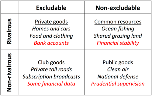
Let's make an important distinction between roadways and highways. Roadways are common resources (rivalrous and non-excludable). Limited access highways are club goods (rivalrous and excludable).
Any network structure (data, telephone, water, electricity, sewerage, roads, highways) has increasing returns to scale, and tends to result in natural monopolies. We recognize that they aren't normal market goods, and regulate them accordingly. Sometimes we mandate competition (internet services), sometimes we socialize them (municipal water and sewer), and sometimes we create regulated monopolies (power and natural gas).
On SLC's wide streets
SLC has the widest streets (132'). It's a quirk resulting from our large blocks, and surveyors convention that the ratio of street width to block size be 5:1 (Our blocks are 660', so it's a 10:2 ratio). In a very limited number of cases, it's handy, as it permits us to do things like have a 24' LRT guideway with 6 lanes of traffic. But most of the time, it's just acres of asphalt. (132' ROW means each blockface represents two acres of asphalt). Some of that gets used for parking, some of it for bikelanes. In other places, we've expanded the 'parkstrip' between sidewalk and curb out 20'. In other places, we've added planted medians with trees.
Tuesday, October 2, 2018
Gentrification / NextCity
Reading this at NextCity
For the sake of argument, let us define gentrification as the replacement of low-income households by higher income households. (Race being associated with income, it is also associated with racial shift). Low income households are almost universally renters. Renters move far more often than owners. Hence, as an area becomes more desirable (for whatever reason) low income renter are replaced by higher income renters. Low income is also associated with youth--incomes tend to rise over time. So as the incomes of low income renters rise, they start buying houses, in the neighborhoods in which they rent. Homeowners typically outbid investors for houses, so owner occupied housing tends to rise. This further displaces renters, as new owners tend to buy the cheapest houses (which are the most run-down, and thus have the cheapest rents). Over time, the existing stock of depredicated (older, run down) housing available for purchase is exhausted. Only nicer, newer, more expensive houses are available for rent--at higher rental costs. The 'climax ecosystem' consists of expensive homes (either owned or rented). The only thing that prevents this dynamic (keeps rents/cost low) is the production of new housing. Initially, it serves to blunt the demand for expensive housing (rented and owned), and reduce the conversion of depreciated properties (for rent or purchase) to restored/new properties.
For the sake of argument, let us define gentrification as the replacement of low-income households by higher income households. (Race being associated with income, it is also associated with racial shift). Low income households are almost universally renters. Renters move far more often than owners. Hence, as an area becomes more desirable (for whatever reason) low income renter are replaced by higher income renters. Low income is also associated with youth--incomes tend to rise over time. So as the incomes of low income renters rise, they start buying houses, in the neighborhoods in which they rent. Homeowners typically outbid investors for houses, so owner occupied housing tends to rise. This further displaces renters, as new owners tend to buy the cheapest houses (which are the most run-down, and thus have the cheapest rents). Over time, the existing stock of depredicated (older, run down) housing available for purchase is exhausted. Only nicer, newer, more expensive houses are available for rent--at higher rental costs. The 'climax ecosystem' consists of expensive homes (either owned or rented). The only thing that prevents this dynamic (keeps rents/cost low) is the production of new housing. Initially, it serves to blunt the demand for expensive housing (rented and owned), and reduce the conversion of depreciated properties (for rent or purchase) to restored/new properties.
Monday, October 1, 2018
Retail, Malls and Amazon
What's the future of retail? Historically, researchers of retail tend to divide it into 'destination retail' and 'convenience retail'. The former is where you journey to visit one specific place, and the latter when you visit the closest place (Ikea vs. Quik-e-marts). Malls used to succeed by attacking the latter to the former: A couple of big anchor department stores, along with shoes/specialty apparrel, jewelers, toy stores, and a few dentists. In effect, malls were artificial 'central places', created through the low-cost transportation provided by freeways. So, thanks to traffic congestion, that 'surge' of accessibility provided by freeways is gone. It it that big of a surprise that many malls are having a hard time? Now, to get you to drive to a destination (given the increased time/difficulty of doing so), it's really got to be something special: higher quality destination retail, things you can only find in place...which is sort of where Amazon comes in--it provides more of the things you can only find in one place. And so all the malls have to provide something Amazon can't provide: An experience of place.
Wednesday, August 22, 2018
Charlotte Transit
Sometimes I wonder if I should just become the 'BRT guy'. Lots of competition to be the 'TOD guy', (most notably Calthorpe and DPZ).
From my NITC Charlotte BRT Report:
This study examines Charlotte’s bus rapid transit line. More properly, the project is an ‘open busway’ without inline stations, served by a two-way exclusive bus-only lanes in the center Figure 1: Example corridor, buffers, and LED census block points of Independence Avenue. While Charlotte has a number of experiments with best bus and bus plus systems, such as Sprinter bus and the Gold Rush Trolleybus, both fail the critical test of a Bus Rapid Transit System: Dedicated guide-way. Charlotte’s bus rapid transit makes use of underused HOV lanes the center of Independence Boulevard. In addition, it enjoys the use of queue jumpers at certain intersections. The 2-way HOV lanes provide 2.6 miles of dedicated right of way. The right of way is typically used by express buses. Buses traveling the corridor originate in the southeast corner of the metropolis, and ends slightly inside the I-485 beltway.
Charlotte also has LRT
This study examines Charlotte’s light rail line, the LYNX. It is a 9.6-mile light rail corridor that began service on Figure 1: Example corridor, buffers, and LED census block points. The corridor chosen for analysis was part of the South Rail Line. For a Comparable corridor, the planned Blue Line/North East extension along the existing railroad to UNC Charlotte was used. Both corridors are existing rail right-of-ways running through the central business district (CBD). Figure 2 shows the transit and comparable corridors as well as the location of LED points.
Sunday, July 29, 2018
Peak Pricing
Hey, DC Metro people: Here's an idea: stop charging based on distance, and start charging based on congestion. The marginal cost of adding one more person to an empty train is basically zero, regardless of how far they travel. But the marginal cost of one more rider on a crowded train is an additional iota of misery for everyone on board the train. Distance based policy just discriminates against long-distance travelers.
The system already tracks where someone gets on/off. Correlating that to their location, and the location on a train during a peak period is trivial. Then you can charge them for it. Some people might get surprised; add a 'peak' light to the train, and start charging on stations after that.
The system already tracks where someone gets on/off. Correlating that to their location, and the location on a train during a peak period is trivial. Then you can charge them for it. Some people might get surprised; add a 'peak' light to the train, and start charging on stations after that.
Friday, July 20, 2018
Owl line, pt 2
A ways back, I posited an 'Owl line' from the Airport to the University. Had a long talk with George Chapman a few months back, who suggested that the Owl Line was kind of a waste of time.
This summer, my step-son is commuting to the Airport from my house (by the U of U). It takes over an hour to reach the airport. And I suddenly realized why I never take TRAX to the airport (it takes too bloody long). Indeed, I once had a professor who would bike(!!) to the airport. But it's only about 10 miles, and a bike travels about 10 miles an hour...so in good weather, pretty feasible.
I know that for short distances, bikes and buses travel about the same speed (it's a toss-up whether I take the bus or bike from my house to Sugarhouse). But it's kind of bleak to realize the same is true over longer distances, and not through a dense, walkable area.
But what makes the TRAX trip so long is not actually the trip--it's the transfer. Rule of thumb is that a transfer requires time equal to half the headway (or 10 minutes if it's a 15+ minute bus). But my step-son tells me that the red line departs (within sight) from courthouse station, right before the Green arrives. So he gets to wait 7.5 minutes to board the Green, and another 15 minutes to board the Red.
Why do people not ride transit? Because it's slow. I recall one city who long-range transit plan was to have a transit trip be no slower than twice a car trip. Which seemed like a ridiculously low standard (at the time). But it's one that that TRAX between University and Airport is clearly not meeting. And the reason for that is clearly the transfer.
Monday, May 21, 2018
Electrifying FrontRunner
Greetings, all.

However, the Surfliner only stops 8 times, while FrontRunner stops 15 times (over 17 stations). Doubling the # of stations would double the number of times FrontRunner could benefit from increased acceleration. FrontRunner is 88 miles long, the Surfliner 125 miles long. So FrontRunner probably spends less time at top speeds, so acceleration is much more important. Surfliner EMU cuts time by 8%, 1%/stop, so we'll assume FrontRunner does the same, cutting travel time by 15%. VTPI suggests a non-linear relationship, with a 15% reduction in travel time resulting in a 20% increase in ridership. Wiki says daily ridership is 17,600, so that would bet 3,520 new daily riders.

Future UTA does a nice job discussing electrifying FrontRunner. It notes that "electric traction can substantially increase the rate of acceleration trains are able to achieve, thus reducing trip times".
The benefits of doing so are uncertain, and calculating them is complex. Reason&Rail did so for the Amtrak Surfliner. He gives the number of $3.6m/mile, based on estimates for California's HSR.
Take-away is that shifting from a diesel train pulling cars (like FrontRunner) to electric multiple units doesn't seem to save much time.
However, the Surfliner only stops 8 times, while FrontRunner stops 15 times (over 17 stations). Doubling the # of stations would double the number of times FrontRunner could benefit from increased acceleration. FrontRunner is 88 miles long, the Surfliner 125 miles long. So FrontRunner probably spends less time at top speeds, so acceleration is much more important. Surfliner EMU cuts time by 8%, 1%/stop, so we'll assume FrontRunner does the same, cutting travel time by 15%. VTPI suggests a non-linear relationship, with a 15% reduction in travel time resulting in a 20% increase in ridership. Wiki says daily ridership is 17,600, so that would bet 3,520 new daily riders.
88miles*$3.6m/mile is about $315m for electrification. $315m/3,520 gives a cost of about $90k per new system rider. Which is very very high, higher than most heavy rail projects. ...and better than some light rail projects. By Montreal standards, pretty high.
Again, a back of the envelope calculation says it's not worth it. This calculation does not include pollution costs or savings in fuel costs, or savings in travel time etc, so it's not a cost-benefit analysis.
Friday, March 30, 2018
FrontRunner as symbolic unity
Not sure if you know it or not, but a few counties in Utah contain almost all of the population. Salt Lake, Utah, Davis are something like 70%. Adjacent counties (Wasatch, Tooele) are maybe another 5%, and Washington County (St.George, Cedar City) are the other 20%.
FrontRunner now links Salt Lake, Davis, and Utah. So 3/4 of the population is in a county with FrontRunner. The share within a mile of FrontRunner is likely even larger. Ideally, we can use FrontRunner as transit spine for the whole region, with TRAX/MAX lines branching off at all the stations.
FrontRunner now links Salt Lake, Davis, and Utah. So 3/4 of the population is in a county with FrontRunner. The share within a mile of FrontRunner is likely even larger. Ideally, we can use FrontRunner as transit spine for the whole region, with TRAX/MAX lines branching off at all the stations.
Friday, February 16, 2018
Uber as a congestion pricing beach-head?
"The policy journey of São Paulo, Brazil, a vast metropolitan region of 20 million people, has been telling. The city council initially banned all ride-hailing services via apps, spurred on by allies of the taxi industry. Other parties, recognizing the inevitable popularity of Uber as well as two more homegrown companies, 99 and Easy Taxi, pushed back. The compromise allows the companies to operate, but charges them for the use of streets per mile. A sliding scale was established—more if in the city center during peak hours with only one passenger; less for more passengers, cars in underserved areas, electric vehicles, women drivers, and accessible vehicles. A standing committee meets regularly on whether the charge needs to be modified. In the process, the city gets some raw data that can help with mobility policy.
The charges—for the privilege of using a public asset, the roadways, for commercial purposes—are estimated to bring in $50 million per year. Nearly a year after the policy was set, the experiment is going well, said Ciro Biderman"
Thursday, January 25, 2018
The Owl Line
I've written previously about an 'Owl' line for TRAX, running from the Airport to the Univerisity Hospital.(Map)
Today, I read a Tribune Editorial which said:
Today, I read a Tribune Editorial which said:
Honestly, to justify the more expensive station, we may eventually to have to throw in even more money. Specifically, the trains need to start earlier and run later to catch more airport employees and travelers. (Current ridership to the airport is about 1,100 per day.)UTA can't run TRAX any later due the deal they cut with Union Pacific regarding use of the rail-road tracks TRAX runs on, viz: UP gets to run freight on the tracks after midnight. But it's only on the part of the Blue line south of about 1100 South. So an 'Owl' line, running up to and after midnight, could be run on the street-running portions of TRAX. The termini on each end (the airport and the hospital) are both 24 hour destinations. However, the majority of the ridership for both of those destinations are going to come from employees, and TRAX doesn't connect to the lower income neighborhoods where orderlies and baggage handlers make their homes. (There is a reason that the Green line connects to West Valley). Given that we can't make that connection by TRAX, it will have to be by bus. Given the distances, it should likely be BRT-like (ie MAX). Currently on the planning books are two N-S corridors, 5600 W. and State Street. Operating those two routes on longer hours, in combination with the Owl line, would provide access to 24-hour employment at a large number of destinations. Running through SLC downtown, it would also serve the cleaners/janitors, and may, just maybe, the bar-going crowd...
Thursday, January 4, 2018
Missing Interchange in Utah County
I'm mapping interchange frequency in Salt Lake and Utah County, to determine if another interchange is needed at the Point of the Mountain. (The answer is no).

Most interchanges are 2 miles apart, or less. There are a number of gaps (20th East and I-80, 5400 South and I-215) but mostly the 'buffer' overlaps, indicating that we likely have too many interchanges. Utah County has some gaps like might bear an interchange, like 900 N. in Lehi and I-15, or the Westview Industrial Park. But the BIG gap is between the Provo Center Street and University Parkway. They are over 18,000 feet (~3.5 miles) apart. Which is a big deal, because BYU is due east of that point...

An interchange at about Provo 1500 N. seems to be missing. A split interchange, connecting on 1640 N. to the west, and 1480 N. to the East, would do a lot to fix that. You could drive from I-15 along 1460 N. to Grandview Lane to Columbia Lane to Bulldog Boulevard and into BYU, passing the Utah Valley Hospital along the way. (820 N. would be a viable alternative).
Ideally, it could just be built as a HOT/HOV ramp. Satisfy transportation demand without unleasing a horde of vehicles on the street.
Subscribe to:
Posts (Atom)