TOD emerges from a 'Joint Development' context, which it fell under the aegis of Redevelopment Agencies. The amount of developable land in the quarter mile radius around a transit station is small enough the become a 'project' for a redevelopment authority, rather than a planning-scale enterprise. This has both benefits and hazards. They can be prone to monopolistic situations where a single owner declines to develop. They can also be 'sterilized' by administrative, legal, or topographical complexities.
Development is not autocatalytic process--it needs something to start it. A 'landmark project' can set the tone of an area. A quality new building is a neighborhood amenity, and can catalyze a 'virtuous cycle' of public investment, rising amenity, & private redevelopment. So can a major public investment.
The primary value of any property has little to do with the property, and everything to do with the location of the property.
Monday, September 30, 2013
Ridership and Service
The relationship between ridership and service is not linear, but elastic. Ridership declines more than a proportionate cut in service would suggest, as transit relies on a 'network effect'. As service declines, ridership declines more. The opposite is true of service frequency. Doubling the frequency more than doubles the ridership. There is a lot of 'latent demand' for transit service that is never met. Transit agencies are effectively 'monopoly providers' of transit service. Not just because of their public
An effective private transport network would need to include a mandate that all operators honor each others tickets. And were fairly compensated for doing so. Because when it comes to networks, transfers are the name of the game.
***
Service has two components: Coverage and Frequency
Coverage: "Can I get there?"
Frequency: "How long until the next one comes?"
***
Fast, frequent and reliable BRT service to act as a 'trunk line', facilitating transfers. Transfers are brutal when the 'transfer penalty' is 10+ minutes on a 30 minute journey. Half headway is the typical calculation of transfer penalty. I'd say it's more like headway, because the uncertainty about bus location doubles the stress and hassle. Have you just missed the bus? Is it coming? And will it stop when it reaches my stop? The last one kills me--means I have to be constantly 'on guard', while at a TRAX station I plop down and open a book.
Grading BRT
Fare Collection
A - Free
B - Offboard
C - Onboard
ROW
A-Grade Seperated
B-Exclusive
C-BAT Lane
D-Mixed Traffic
STOPS
A-Median Dedicated
B-Flush-curb/level boarding.
C-Curb & gutter
-1 for Bus Pullouts
Peak Headway
A-5 min or less
B-10 min
C-15 min
Worse Headway
A-10 min or better
B-15 min
C-20 min
Stop Spacing, Average (Difference from mean of 1/2 mile)
A - <.1
B - <.2
C - <.3
Stop Spacing, Deviation from Optimum
A- σ<=.1 miles
B- σ<=.2 miles
C- σ<=.3 miles
Have to do something about the DISTRIBUTION of stop spacing, not just 'average'. Perhaps something with standard deviations?
σ<=.2 miles
What else matters?
Operating Hours out of 24 (buses per day? Per week?)
...so much of ITDP only applies to developing world 'Surface Subways'
Propulsion Tech
A- Electrified
B - CNG, etc.
C- Diesel
Wheelchair boarding
-Boarding plates
-Wheelchair lift
STOPS
-Stop request signals
-NextBus information (realtime passenger info)
-System Map
-Area Map
-Schedules
-Seating
Bike integration?
Multiple-Door Boarding
Intersection
-Transit Signal Priority
-Queue Jumps
A - Free
B - Offboard
C - Onboard
ROW
A-Grade Seperated
B-Exclusive
C-BAT Lane
D-Mixed Traffic
STOPS
A-Median Dedicated
B-Flush-curb/level boarding.
C-Curb & gutter
-1 for Bus Pullouts
Peak Headway
A-5 min or less
B-10 min
C-15 min
Worse Headway
A-10 min or better
B-15 min
C-20 min
Stop Spacing, Average (Difference from mean of 1/2 mile)
A - <.1
B - <.2
C - <.3
Stop Spacing, Deviation from Optimum
A- σ<=.1 miles
B- σ<=.2 miles
C- σ<=.3 miles
Have to do something about the DISTRIBUTION of stop spacing, not just 'average'. Perhaps something with standard deviations?
σ<=.2 miles
What else matters?
Operating Hours out of 24 (buses per day? Per week?)
...so much of ITDP only applies to developing world 'Surface Subways'
Propulsion Tech
A- Electrified
B - CNG, etc.
C- Diesel
Wheelchair boarding
-Boarding plates
-Wheelchair lift
STOPS
-Stop request signals
-NextBus information (realtime passenger info)
-System Map
-Area Map
-Schedules
-Seating
-GTFS feed
-Automatic Vehicle Information
Multiple-Door Boarding
Intersection
-Transit Signal Priority
-Queue Jumps
Modeling Transit Netowrks
Transit NETWORKS rather than transit LINES. Really need some transit network metrics. An index or transit networks, which covers frequency, travel time...not mode. Connections, count of nodes, that is the important thing. Do two co-linear lines count as connections? Yes, but with transfer penalty.
Need an index. Index is of what? Of the network. But I also need a 'score' for the entire network. Transportation networks use 'delay'. (Think I can use travel modeling software for this.) Two parts to it, though. The network and the TAZ. Socio-economic data is pretty easy to come by. LEHD, use the LODES, and I've got a trip-matrix.
Less frequent service makes transit journeys take longer, so it is equivalent to congestion?
BRT as streetcar replacement
Places that once had streetcar are now getting BRT. Because the areas were originally 'TOD', the urban form is a good fit for BRT.
Monday, August 12, 2013
Transit Heirarchy
- The Frequent Network runs often enough that you don't have to plan your trip around a timetable. That typically means every 15 minutes or better all day, but it needs to be more frequent than that where aiming to serve relatively short trips -- as in the case of downtown shuttles for example. If you aren't willing to plan your life around a bus schedule, you are interested only in the Frequent Network.
- Infrequent All-day services are the rest of the service that runs all day. This network often relies on timed connections.
- Peak-only service exists only during the peak period. It mostly takes the form of long commuter-express routes that add lots of complexity to a system map but represent very specialized services for limited markets.
I just keep reading Jarret Walker, and just keep understanding more. It's like learning to paint from one of the 'Old Masters'.
Also related: The idea of a 'visual heirarchy' of transit lines.
Access Points for residential subdivisions
City codes typically mandate a certain width of road--typically enough for two travel lanes and on-street parking on both sides of the street. Developers like to minimize the amount of road per subdivision. Which makes sense. Grass is cheap, asphalt is expensive. They also like to minimize 'through' traffic, and so the development plats tend to have a single exit per subdivision. Which is great if you live in that particular subdivision, but hell on walkability. It's also hell on the performance of external streets--instead of some of the 'local' traffic taking places on these local streets, it all gets dumped onto high speed arterials...disrupting traffic flow, and slowing traffic. Which is problematic, as arterial streets are much much more expensive to build that local streets. And, if the traffic volumes coming out of a residential subdivision are high enough, may make it necessary to have a traffic light, at additional cost to the city, and impairment to the function of the road. Western Hills Drive, in South Jordan, is a fine example of such, with over 200 houses, and only one access point.
Adding more access points in a residential subdivision means fewer cars turning in an out of a subdivision, as use of the access is divided over more points. It also means that residents get off arterial streets faster, as they can take the more direct route to their homes, rather than needing to circle the block first. Quality city planning also mandates that developers include 'stub' streets. Streets that do not (as of yet) connect to anything, but that will connect whatever gets built in the next parcel over. Wondering if it might not be possible to go one further, and add a calculation such that there must be 1 'access point' for every 10 acres, or for every 70 units. (Or some similar ratio).
Adding more access points in a residential subdivision means fewer cars turning in an out of a subdivision, as use of the access is divided over more points. It also means that residents get off arterial streets faster, as they can take the more direct route to their homes, rather than needing to circle the block first. Quality city planning also mandates that developers include 'stub' streets. Streets that do not (as of yet) connect to anything, but that will connect whatever gets built in the next parcel over. Wondering if it might not be possible to go one further, and add a calculation such that there must be 1 'access point' for every 10 acres, or for every 70 units. (Or some similar ratio).
Thursday, August 8, 2013
Free Transit in Talinn
Interesting.
Not free for just anybody, and not anonymous. Similar to a driver's license, where it is both license and form of ID.
"Starting this year, all residents of Tallinn can use public transport for free but they have to acquire a personalized public transport card and register it when entering the public transport vehicle. All Estonian pupils up to the age of 19 and other groups of people who have the right for free public transport have the right for free transport in Tallinn."
Monday, April 15, 2013
Neutral ground
Salt Lake City has ridiculously wide streets. Inhumanly wide. They've made car travel much easier, because it's possible to fit 7-8 lanes of traffic down one street without it being too much of an issue. Even on 400 South, where the light rail is, there are still three lanes of traffic on both sides.
On my street (1200 East) they've fitted the street with very large central islands. It's a residential street, with no need for the width for traffic, so the islands cut it down to something much more reasonable.
Specifically, I am thinking of Salt Lake's effort to transform some of the streets into 'bike boulevards'. Take 500 South. It originally looked like thus. Currently, one the lanes has been removed, and re-striped as a bike lane. A mess of orange bollards has been erected (also making it impossible to plow). Not a fan.
But it makes me wonder if it might not be possible to do something that looks a little nicer, and combine the two. Borrow something from the 'neutral ground' idea that prevails on the New Orleans tram (and the Eugene BRT.
 Viz: Rather than bus lines down the side of the street, a big central green-space with bike lanes running down the center of the street. Grass lasts longer than paint (being self renewing), and would reduce the total volume of street needing paved.
It would have to be wide enough to run a snowplow down, though.
On my street (1200 East) they've fitted the street with very large central islands. It's a residential street, with no need for the width for traffic, so the islands cut it down to something much more reasonable.
Specifically, I am thinking of Salt Lake's effort to transform some of the streets into 'bike boulevards'. Take 500 South. It originally looked like thus. Currently, one the lanes has been removed, and re-striped as a bike lane. A mess of orange bollards has been erected (also making it impossible to plow). Not a fan.
But it makes me wonder if it might not be possible to do something that looks a little nicer, and combine the two. Borrow something from the 'neutral ground' idea that prevails on the New Orleans tram (and the Eugene BRT.

It would have to be wide enough to run a snowplow down, though.
Friday, April 12, 2013
Center vs. Side Running BRT
Reading up on the issue at the Transport Politic, and a few issues need to be brought up.
URBANITY Center running is more 'urban'. It is more pedestrianized and more walkable, because the station on a center-running alignment acts as a pedestrian island, making it easier to cross even very wide streets. 400 South in Salt Lake has THREE lanes on each side the TRAX, but is easier to cross than 500 South, which has only 2 lanes in each direction. The dual left turn lights along 400 South means that one side of the road is frequently empty, making it possible to jaywalk with impunity.
STUCK. Using the curb lanes, their is concern about buses getting stuck behind right-turning cars. It's really a non-issue. Getting stuck behind left-turning cars (for center running) is a far more severe issue, from a traffic engineering point of view. It takes a lot of 'green time' on the signal to turn left, so even a few cars can be a delay, while it takes a LOT of cars turning right to slow a bus. Far more likely in my experience has been cars stuck behind a bus at the light....
Which brings up another point, FAR SIDE STOPS. Bus stops need to be on the far side of the intersection, rather than the near side. I know, near-side stops *seem* to make sense, as buses stopped on the red can board passengers...except that doesn't work. The timing never syncs up, and it forces buses to wait through two cycles of the light. A stopped bus also conflicts with cars trying to turn right.
Worse yet, on streets with right turn lanes, the bus has to pull out of traffic to load passengers...and then merge back in. It's the same issue with BULB OUTS. Bulb-outs suck. Traffic engineers may like them, as they get the buses out of the way, but the best part of all the BRT's I've been on (Eugene, Phoenix, Boston) notably lack them.The bus comes to a stop, boards, and rolls on.
Which brings me to the issue of CURB HEIGHT. To aid on 'level floor boarding' (including Roll-on-Roll-off in Eugene) the curb height is raised. Buses no longer need to 'kneel' or use lifts to pick up wheel chairs, and everyone boards faster (walking along the ground being faster than climbing up stairs). Curitiba used raised platforms for it's famous BRT network, and they have work out well.
But high curbs do more than that...they also solve the GUTTER problem. People waiting for the bus in the rain getting splashed by spray from the gutter is so common in movies it's almost at trope for 'bad day'. It's actually worse in real life. Even if the bus driver is careful, and rolls up s-l-o-w-e-l-y, he's not going to be flush with the curb. There will be a gap between curb and bus (about a foot) filled with six inches of gutter water. A veritable moat. Me, I just leap it. For little old ladies...the wheelchair lift has to come into play. Which takes FOREVER.
Regarding WHEELCHAIRS....whatever buses Lane County Transit (Eugene) bought for it's BRT...buy those. I thought they were just the new standard for buses, until I rode the Valley Metro (Phoenix) BRT. The bus rolled up, front and rear doors opened, the wheelchair ramp extended onto the platform, *two* wheelchairs rolled on, and into wheelchair slots directly across from the door, locked the wheels on their wheelchairs, and the bus rolled on. You know, like they were normal people. The driver never even got out of his seat. Phoenix...still with the special wheelchair lift, driver assist required.
Wednesday, April 10, 2013
Friday, March 22, 2013
Wednesday, March 20, 2013
Atlanta Streetcar Loop
Looks like the Feds actually funded a 'loop' streetcar in Atlanta. I will be very interested to see how well it works out. 'Loops' are very attractive politically, because they provide a mechanism for more places to be adjacent to the line, but are operational failures. It's broadly acknowledged in transit planning that circulators don't work--downtown 'shuttle' services (rail or not) rarely have enough ridership to make them worth the cost, largely because its simply faster to walk than to wait (an infuriating situation). The 'river ratio' of straight line distance between endpoints vs. track length remains a very good determinant of transit line 'goodness' for a reason.
Working on Ogden Streetcar, I fought the idea of separating the streetcar lines into two uni-directional lines because I believe it makes riding the system more difficult. I recently rode Phoenix's LRT, which has directionally separated track--although only by 1/8 mile. I did not like it--I found it made using the system more confusing--I could not just walk back to my origin point to get back on the train, but had to find an entirely NEW location to do so.
The Atlanta streetcar is separated by 1/8 mile, but also includes a larger loop on the western end. It *may* be long enough to be worth riding (instead of walking). The 1/8 mile metric is significant because that's a SLC block--and if it works in Atlanta, it'll work here. IF it works in Atlanta.
Wednesday, February 20, 2013
Direct Service & Express
Express to the U
Earlier, I wrote about the attractive potential of starting a ride-share of 'caro publico' between the Salt Lake Central Station and the U. While it looks like I was right in predicting the demand for quick passage between the station and the U, I was wrong about the mechanism. Rather than an on-demand service to the hospital, there is a enough demand for a shuttle.
The 'directness' seems to be the important part. It may be useful to start thinking about high-capacity transit in the same way we think about air-lines--as rapid transit between hubs, rather than as service along a route. Certainly, it seems like a waste of time not to pick up passengers along the route, but it's a matter of aggregate delay. Stopping a shuttle with 20 people on it 6 times to pick up six passengers (even if the stop is only 10 seconds) is still 20+ minutes of delay.
But the power of a shuttle is that it can do just a little more than a plane (which is hub to hub). You can also have some stops 'after' the end of the 'direct' route, so you can distribute passengers around an area. It's a stopping pattern I'm seeing a lot in light rail---a long 'direct' section, and then a large number of stops downtown.
Direct: x--------------------------x
Direct Plus: x-----------------------------x--x--x--x
Local: x--x--x--x--x--x--x--x--x--x--x--x--x--x--x
Rapid: x----x----x----x----x----x----x----x----x
Too many stop: x-x-x-x-x-x-x-x-x--x-xx-x-x-x-x
(Presume each dash is 660'---a SLC block.)
I increasingly believe that a great deal of the value of fixed-guideway transit is coming from stop spacing. Expensive stations means fewer stations, which means fewer stops,which means better speeds, which means people are willing to walk further (or wait longer).
Tuesday, February 12, 2013
Hex City II

The blue and green streets are one-way streets in the direction indicated. The red and orange are two-way streets, with a wrinkle--on the orange roads, the you drive on the left, rather than on the right (with a visual barrier between, to prevent confusing drivers).
The result of this complicated pattern is that every single turn you make on the network is a 'safe' turning movement that does not require crossing traffic, so there is no-need for stop-signs or traffic lights, only terminating turn-pockets onto and off of roads. Consequently, you can go pretty much as fast as you like.
The turning rule is: You never cross traffic. So you can go left from green onto yellow, and from blue onto yellow. The rule ought to have been 'rights onto red, lefts onto yellow'.
Travel in the NW-->SE direction(blue, green paths) is fast direct. But travel in the NE-->SW is a pain (gray path), because every other road you have to take a 'red' street, and wind up going about 50% more distance. I think the lack of streetlights would be worth it, but not sure. The plan would be most suitable for a city where most of the travel is in one direction, such as a mountain valley.
I can't see retrofitting an existing city, but it would make a novel subdivision plat, or the traffic plan for a tabula rasa city like Brasilia or Masdar.
For local streets, connecting these main-streets, you can do pretty much what you want, with some limited exceptions: The turn pockets have to be oriented toward the direction of flow, so as not to generate temptation to 'cross' in front of traffic, on red or yellow streets:
Comments:
- practical problems: will ignore drunk drivers, but how about people who aren't spatially inclined? I could imagine getting lost *extremely* easily.I don't propose to make this real in the least--it's a bad idea in a multitude of ways. It's a traffic network for SimCity, or for Traffic Simulation software. If you are working with a 'omnipotent' traffic allocator, which knows the whole network (and never gets lost) it just chooses the most direct route for each residential cell and the nearest employment cell.
A system like this would drive most people nuts. They would have to constantly be aware of where they are because if they miss a turn, its much more costly, timewise, to correct it than on a square grid.Most places don't actually HAVE grids, or ones of analogous scale. Grids are more the exception than the rule, actually. Phoenix has one due to it's near-total lack of geography (rivers, mountains, valleys, etc).
Hex City III

- With such a street network, you can do some funky things with the signals. For example: Use three-phase signals, so each of the 3 directions are 'green' in turn, for right or left turns. Or put a roundabout at each intersection. You could also make some of the legs one-way streets...SimCity Traffic network 2 - trinary. More geographically uniform, with three directions instead of 2.The signals alternate by street color. For example: At a given intersection, on red's 'turn': Cars on a red street may turn left or right, cars on a green street may turn right, and cars on a blue street may turn, but must yield. Then it's blue's turn, then green's, then red's again.At any intersection, 4 of the possible 6 turning movements are being made at any given time. Traveling in as straight a line as possible, a driver will have to make a left 50% of the time. At a given intersection, 33% of the time they will immediately be able to make a left. So chances of stopping (for a straight path) at any given intersection are about 1 in 6. Half of those stops will require waiting for one color to go, and half for two colors to go.Single and double lanes only. The grid-scale is analogous to secondary arterials, at mile to half-mile spacing.High-traffic places would have traffic arrows to tell you when you can go. Medium traffic places would have a two or 3-way stop, and low-traffic locations would have zero or one stop-sign.
Monday, February 11, 2013
Hex City I

New SimCity coming out. Hopefully it will be at least as good as the first one. Early indicators are not positive...
But it inspired some interesting comments...
"Could you imagine driving in a city layed out like that? every 100 feet a stop sign or traffic light. On the other hand, everyone has a park in their backyard"
Yes and no. With such a street network, you can do some funky things with the signals. For example: Use three-phase signals, so each of the 3 directions are 'green' in turn, for right or left turns. Or put a roundabout at each intersection. You could also make some of the legs one-way streets...
Monday, January 28, 2013
Some Thesis on Transit
Goodness of service is measured in ridership per route mile. There are no other metrics.
If the service is good, people will ride it. The better the service, the more people will choose to ride it. Many things contribute to goodness of service--Speed, Frequency, and Reliability are all important.
Why per route mile? If half the route length is junk, the numbers should reflect that. If cutting half the route destroys the whole route, it is not a very good route.
There is no help for a route that does not connect to places people want to go. If it goes someplace useful, it will be ridden.
Ridership per route mile does not measure development effects. Development does not affect goodness of service. Development is caused by goodness of service.
For planned routes, for which not ridership can be given, accessibility to jobs and employment (as measured by density) is a reasonable proxy.
Transit use is mediated by the attractiveness of alternate forms of transportation. The difference in time and cost between transit and alternatives is critical. ie: Parking availability, congestion, gas prices.
Friday, January 25, 2013
Phoenix 2013 - Barely a BRT
Last weak, I visited Phoenix, Arizona. While there, I took the time to ride both the Metro light rail (which is excellent) and the LINK bus rapid transit (which is not).
LINK BRT
Link was a) late, and b) not keeping to its headway. According to the schedule, it was on a 15 minute headway, but I waited over 20 minutes. The reason for which quickly became apparent--the entire boulevard was torn up on one side, with one lane in each direction.
The buses are branded, but they use a combination of articulated and non-articulated buses. The presence of 'normal' buses was upsetting--if you can't fill the bus to capacity, how good can your bus be?
For a state with so many old people and veterans, valley metro is inefficient at loading wheel chairs. The sliding-board on the Eugene BRT really impressed me. In Eugene, wheel chair riders roll themselves on, and then back into a little slot directly across from the back door, where they boarded. The wheelchair ramp is activated by the driver, from where he sits. On the Link, it was much more like a regular bus. The driver got up, walked back, opened the door, made everyone standing move, lowered the ramp like a draw-bridge, let the guy roll aboard, made more people move, flipped up some seats, seat-belted the wheel-chair in. Then he turned to the old lady in a wheelchair on the platform, shrugged, and said 'There'll be another bus along in a moment'. It was like watching a transit horror story, enacted before my very eyes.
Station spacing was a little enraging. Multiple times, the stops are still near-side of an intersection. Which is two-fold terrible. First, it means a bus will almost certainly miss the light--approaching a green light, the bus will still have to stop, and almost certainly will wind up sitting through the red light. Far-side stops means the bus continues through on the green. Second, near-side stops conflict with with the right-turn pocket, so that the bus has to slow down, pull out of traffic (and into the gutter), conflicting with car traffic. Waiting passengers are also exposed to the constant screech of right-turning cars. I began to wonder how 'seriously' Phoenix had taken the whole concept of BRT
On-board fare collection for the Phoenix LINK. I had a transfer ticket from the light rail, so I didn't notice it at first. Many people had contact-less fares, but there was still a certain amount of fiddling with the machine, cramming creased dollar bills into the slots, as the whole bus sat and waited.
The lack of offboard fares made me wonder about how 'substantial' the stations actually were. I was not impressed. The area tends to substantial bus stations in any case, due to the absolute necessity for shade. The BRT stations were larger, with more metal and more seats....and that was it. No 'Nextbus' indicator, no offboard fare collection, no informational materials, nada. They do tend to have the raised curb that permits for level boarding, (which seems to be universal for BRT).
No bikes on the bus. Again, the innovations of Eugene are telling. Link had spots for TWO bikes (no more) attached to the front of the bus, like a normal bus. Eugene permitted bikes on the bus, in a spot between the 'flex' spot and the wheel-well.
The Phoenix Link was brutally slow. Start to end was a solid hour. Even including the delay from construction, that's a very long line. (And the longer the line, the greater the danger of delays and the more the difficulty of keeping to a schedule.) But, as one local put it: "Beats taking the local bus". There is a local bus running the same route, stopping more frequently. I can't even imagine how long it must take. Hours.
At one station, there was actually a driver switch. Another driver was waiting at the stop (which was next to a convenience store (bathrooms+food), and took over driving the bus.
Superstition Springs Transit Center was actually pretty innovative. Good urbanism, fitting a new use into an old context. It's a park and ride lot situated on the edge of an older mall, where the most distant, marginal parking would normally sit. The access is provided by a ramp from the freeway on-ramp, so it's very direct--no detours through the mall parking lot. Two kinds of bus parking--one for buses you can board, and one (less accessible) for buses that are idling. And for the drivers, the Mall is both food-court and bathroom. Not to mention a major retail center. The only problem is that there is absolutely nothing BUT the Mall--a very 'mall or death' context.
METRO light rail
First, I was struck by how long the dwell time at the stations is for Metro. TRAX arrives, the doors open, people get off, people get on, and whoosh, it's gone. Metro seemed to sit a bit, which I found a bit strange. It's got low floors, which should speed boarding for both regular and wheel-chair riders. Perhaps it has a 'dwell' point in the mid of the system intended to provide a buffer if it's running late?
Secondly, it didn't reach downtown Mesa, somewhat to my confusion. Downtown Mesa had been the planned terminus for years. Instead, it stops about a half mile away, near a transit center. It's not an unreasonable terminus, but if the intent was to provide increased accessibility, so as to induce redevelopment, it failed. Several museums, restaurants, and government buildings are all in downtown Mesa, as well as a lot of aging 'mainstreet' style buildings.
As I walked the LINK route, I saw a sign stating "Future route of Metro light rail"! I have never seen so clear an example of BRT being used as a 'pioneer' for light rail. It also went a long way to explaining some of the crap-tastic elements of the LINK BRT route--they were never intended to last, and were only temporary placeholders for the light rail.
Thursday, January 24, 2013
Phoenix 2013 Real Estate
Retail space in Arizona must be savagely vacant. So many vacant buildings! So many marginal businesses! (Pawn shops, thrift shops, etc). Assume vacancy varies with age of structure, so that the older buildings are the more vacant. But still! It makes so many marginal businesses possible.
Development is the competition between parcels (via their owners) for value adding development?
Sometimes the disamenity of proximity is sufficient to prevent adjacent land from developing. Where the land is cheap...
Development is the competition between parcels (via their owners) for value adding development?
Sometimes the disamenity of proximity is sufficient to prevent adjacent land from developing. Where the land is cheap...
Tuesday, January 22, 2013
Standing on buses
My personal transit trifecta is 'Fast, Frequent, and Reliable'. I'm much less concerned about comfort, especially for shorter trips. For anything under a mile, I'm happy to stand. And willing, for much longer distances. But it is not so much the distance as the time. I stood for 20 minutes on the Eugene BRT, and was not unhappy for it.
The bus was not over-supplied with seats, but had plenty of wheelchair and bike space.
The bus was not over-supplied with seats, but had plenty of wheelchair and bike space.
Friday, January 18, 2013
Nature Chair
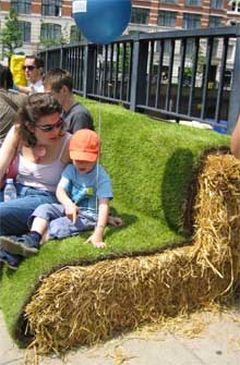
Amusingly, 'Nature Chair' was a commonly used search term for this blog. So let us have another! Very nicely done, actually. Public seating, to convert hard-scape and the dead edge of a wheelchair ramp becomes public seating. The hay bales provide support, and an organic matrix for the grass to grow into. Certainly, they will dissolve over time, but cellulose dissolves slowly, while it's cheap enough to do quickly as almost an experiment.

Saturday, January 12, 2013
Market Demand
Let us put a stake in the heart of the idea that sprawl is a market-created phenomenon. Sprawl is a dystopian outcome created by market-distorting regulation. Two specific factors that should be noted are the multi-billion dollar investments in roadway infrastructure, and zoning. (Someday, it would be interesting to suss out exactly how much of the value of suburban land is actually created by transportation investments). Of the two, zoning may actually be the more damaging. Many jurisdictions simply legislate the economically 'highest and best use' of the land (apartments) out of existence. And then compound that problem through the use of minimum lot sizes, so small houses (starter houses, bachelor houses, granny flats) cannot exist. Therefor, there exists not variety in housing types. Think of it as an analogy for stores--"No store of less thant 50,000 SF shall exist". And then no shop smaller than a Wal-Mart could ever be built.
Subscribe to:
Posts (Atom)