Showing posts with label streetcar. Show all posts

Monday, April 6, 2026

Nothing Bore Fruit

Cincinnati's abandoned subway is a cautionary tale about the dangers of planning rapid transit based on corridor availability rather than demand. Admittedly, the Great Depression was an absolute reaper for in-process transit capital projects. But the fact that it was 'originally envisioned as a loop' is an immediate red flag on the 1925 planning. And.... some quality time with Google map suggested that 1925 loop was itself planned on the basis of corridor availability -- cobbling together a series of available existing railroad corridors (B&O, PRR) along with the canal path, with some handwaving on the connection through downtown.  So even if the subway segment was a good idea, the plan in which it was embedded was suspect. 

But that's not an issue specific to Cincinnati - planning from that era in general is suspect--nothing bore fruit--there were zero new rapid transit systems between 1908 and 1972 (although a few cities (Cleveland, PATCO) converted railroads or streetcars to rapid transit systems during that time).


Wiith regard to the project's continued abandonment. An amazing corridor exists, but thanks to Urban Renewal, the conditions that made it a good idea in 1925 no longer exist. 

Which is a problem. People suggest things like "Oh we have an abandoned rail line, you should add light rail" or "We had streetcar here in 1925, so you should put it here in 2025" as if land use isn't fundamental to transit feasibility. 

Monday, February 23, 2026

Kansas City Streetcar, fixed guideway transit, and marginal pricing.

Wikipedia tells me that the OKC streetcar, post-pandemic, was costing $420k a year, collecting $60k a year in fares, for a net loss of $360k a year. With perhaps 15k riders, that's about $23 dollar per rider, which is absurd. So, I hope the areas it is serving are experiencing a whole lot of additional economic activity and new development, because that's a lot. 

More absurd is that a few years earlier, it was free to ride but had 75,000 riders. So the math says $420k a year, collecting $0k a year in fares, for a net loss of $420k a year, for a cost of about $6 per rider. So running things fare-free, they were getting 4x the benefit! 

The case for 'free buses' is often questionable--is the reduced travel time reduced stop times worth the reduced fare? But for fixed guideway transit, the calculation is different, because a fixed guideway transit system already represents millions in fixed costs investment. The OKC streetcar was built on the cheap, for $23m. So assuming a (SWAG) of 4.35%, they are already paying a million dollars a year of interest on the debt to build the thing. So its not $420k to operate, it's 1,420k to operate. Which, at 15k riders, is ~$94 a rider. BUT! At 75k riders, that's ~$19/rider. 

Once you've built a thing, your best option is to maximize the service you are providing. And the way to do that is to make the marginal cost of people using the service as close to zero as possible. And the way to do that is a pass system. My yoga studio runs $150 a month or $30 a class. And when I'm on a per-class basis, it makes me reluctant to take a class. But while I'm on the monthly pass, I've got every incentive to maximize my use. And that's exactly the logic every fixed guideway transit system should be exploiting, because their marginal cost of additional trip is very small, and their fixed costs very large. 

Of course, during the commute peak, transit capacity actually matters and its standing room only. But that's a fraction of the day, and the rest of the day should have discount pricing. Restaurants don't have 'happy hours' because they want you to be happy--but to draw people in during a slack time where they have to 'staff up' prior to the peak, and so they suffer the costs regardless. 

Monday, September 23, 2019

Medium Capacity Metro Systems

I was just reading up on Medium Capacity Metro systems, and one column listed capacity per hour as a criteria (20,000-30,000 persons per direction per hour) and it made me wonder how the UTA Trax stacks up. Years ago, a Portland planner explained the virtues of SLC's long blocks--we can run four car trains, when Portland can only run two-car trains. So, how does SLC's capacity stack up?

The Siemens S70 can hold 225 people, at crush loads. SLC can run four cars per train. And I know there are segments of the network that run trains every five minutes (where the blue, red and green lines share track), which is 12 trains per hour.  So: 4*225*12 is 10,880 persons per direction per hour. Which suggests that Trax is not at it's max, it is pretty close to it (10,000-12,000). 12000/4/225 is 13.3 trains per hour, or a train every 4.5 minutes. So Trax is (in certain sections) very close to capacity. And in sections with curves/turns (900 S to 400 S) probably at capacity, and starting to generate delays.

UTA should probably be looking at either an alternate alignment (400 west) through downtown for the green line, or a transit tunnel under the 400 south intersection.   

Friday, June 7, 2019

SLC Streetcar (May 2019)

Not hearing much about it these days. Perhaps simply not a hot topic any longer. The swell of enthusiasm (and consequent Federal funding) seems to have passed, leaving a number of streetcar systems across the US, with varying levels of functionality. (The Atlanta streetcar is a vicious joke, btw). The Transit Politic has them all mapped out, for the curious. But a quick google doesn't show SLC pushing the proposed streetcar very hard. It's on the long range transportation plan (aka 'Regional Transportation Plan', but none of it in the next ten years. (Looks like an extension of the S-line (Sugarhouse) streetcar is planned, up to 2100 S. & 1100 E, which will make it more central. Although I can't imagine what a mess that will make of an already gnarly traffic pattern. It's 1100 East in SLC, but it's where Highland (a former highway) connects to the urban street grid. Highland looks to have been an old trail, and extends all the way south to the Hidden Valley Country Club at 123rd south, so it's one of the few continuous north-south routes, and hence attracts plenty of auto traffic.  Still, it will be nice to bring the streetcar to the center of the business district, instead of stopping an irritating amount shy (and across a busy road) from all the amenities an destinations. It will change the neighborhood, and likely to the detriment of northbound traffic.

SLC may not care. IIRC, 1100 E. is not a UDOT road. (Given that SLC seized 1300 E back from UDOT, I can't imagine they don't also own/control 1100 E). So they get to control the road geometry (lanes, lane widths), and priortizing access THROUGH Sugarhouse is probably not a priority. (TO Sugarhouse, sure).

Sorry to see that the S-line isn't reaching Westminster, which would be the real prize. All those transit-riding students, and Westminster already committed to a 'distributed campus' with their dorm across 2100 south. If the connection was made, Westminster could be further develop the entire area along the S-line as a 'Transit Oriented Corridor', use the S-line instead of campus shuttles. Bet UTA would love the ridership. The BiFG lady is an activist in opposing the extension to Westminster--fear of losing parking? SLC ought to just take the street parking, independently, and end that issue.

Downtown, RTP has two bits, a 1.8 mile segment along 200/100 s. to 600 east. (woo). and a phase 3 extension to 1300 East, and the University. Meh. Can't help but think that the University would be better served by a BRT on 200 East. That far east, potential for TOD (the only real justification for streetcar) is limited. Envision Utah map clearly shows a bunch of high-value single family homes that aren't going to redevelop. Without redevelopment, the density is too low to generate any serious ridership. Why spent millions to put a streetcar in front of million dollar houses? It's not like the owners are going to use it enough to matter.


Thursday, February 28, 2019

Want a streetcar? Skip the local MPO

Wednesday, May 24, 2017

LRT vs. BRT

To built more Rapid Transit, it should be BRT rather than LRT. Bus Rapid Transit is simply cheaper per mile, which means more of it for the same price.

LRT's advantages are as much political as technical.

First: LRT's primary advantage is that it can use rail corridors to achieve rapid transit status. Cars can't use railway right of way, so there is no competition with cars. This advantage is not limited to LRT. As both the BRT tunnels in Pittsburgh and the Orange line in LA have shown, BRT can use railway right of way quite well. Buses, driven by professionally trained drivers, can pass each easily in 22' (11' per bus). I recall the buses in Eugene, Oregon, coming scarily close. (Railway right of way is only ~22' wide at different points, which is too narrow for even two lanes of car traffic 10' lane + 10' lane + 8' safety area + 8' safety area). Word on the street is that international Fire Code mandates 26' of clear space as necessary for emergency operations.

Second, LRT vehicles are heavier, so they stop more slowly, which makes sharing a lane with cars much more dangerous, especially at high speeds, and consequently less likely to happen.A train in a highway median gets to keep its separated guide-way, and no crank(y) politician can change that. BRT 'Freeway Flyers' (BRT in an exclusive freeway lane) inevitably become BRT in a HOT lane, with consequent degradation in speed and reliability. Trains don't have the problem.

There may be one area where LRT has an actual advantage: Elevated track, with very right clearances. There have been experiments with 'guided' BRT, using things like optical sensors, guidewheels, or specially constructed guide-track. 'The Gap' between vehicle and platform can be an issue, and I'm not sure how well BRT does in that regard.

However, a 'train' portion (exclusive/separated) guideway is expensive. Denver, Seattle, and LA all achieved it by putting light rail in freeway medians. LA is increasing achieving it through the use of elevated lines (albeit at very high prices). Seattle has tunneled, at a cost of over a hundred million dollars a mile.

Previously, I've talked only about 'Rapid' transit in separated/exclusive guide-way. If we want to talk streetcars, it's only fair to compare them with their wheel counterpart, buses. The advantage of streetcar is (again) political. Chambers of Commerce like streetcars, due to their permanency. They are also cheaper and less politically fraught. A 'tram'-type light rail (AKA street-car) is cheap, because it runs in dedicated/mixed traffic right of way. So there is no need to take right of way from cars, or eliminate parking. But this type of right of way comes with costs. It makes the service slow and unreliable--it's like a bus on steel wheels.

Streetcars are also (politically) easier to build, because the FTA helps pay for them. Streetcars can get 50% FTA funding for capital expenses, such as vehicles, TSP, and station platforms. There is no reason a bus couldn't enjoy these same benefits.

Thursday, May 18, 2017

Grades of Guideway


Right of way comes in three grades: 'Separated', 'Exclusive', 'Dedicated'.

Dedicated is the lowest grade. A lane nominally belongs to one mode, an obligation more commonly honored in the breach. Think of HOV lanes and bicycle lanes.


Exclusive can be though of as 'excluding'; exclusive use is maintained through barriers. Exclusive guideway is never continuous--there are always gaps in it, typically at intersections.

Separated 
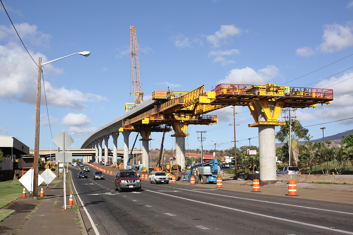
is similar to exclusive, except that it is continuous. Typically, this requires grade separation, if only where the guideway intercepts other rights of way.


Heavy railways (commuter rail, freight rail) have separated guideway, for the simple reason that trains can't stop quickly. Where they must cross other roads 'time-separation' (railroad gates) are used. Where this generates unacceptable levels of delay for the cross-streets (a train can take minutes to pass) grade-separation is used. Typically, this requires an overpass for cars traveling over the road. In cases where there are too many roads, the railroad may be buried. The 'cut and cover' model of a trench with a roof were how the first subways were built. (Actual tunnels came later). In some cases (Alameda Corridor, in LA), digging an uncovered trench for the railway is simpler than many bridges.


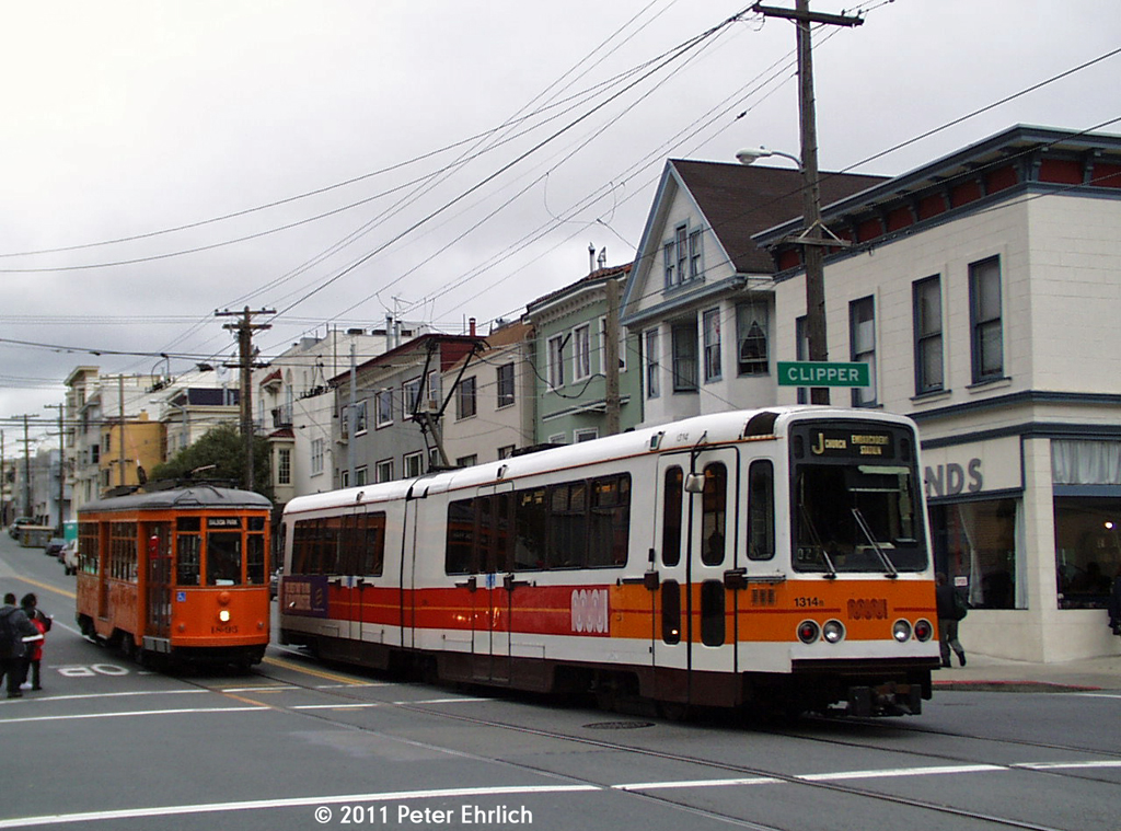
Light railways have a mix of Separated, Exclusive, and Dedicated. Most light railways make use of some portion of old freight track, which are already time-separated. Some light rail systems provide Separated guideway by running down the center of freeways (Portland) or on elevated structures (Los Angeles, Salt Lake). Light rail on streets (a train in in tram-mode) typically has Exclusive guide way, with intermittent sections of Dedicated guide way. San Diego and Buffalo, two or the first cities to build light rail, made use of this. Light rail vehicles weigh less than heavy rail vehicles, and so can stop more rapidly. Streetcar/Tram vehicles weight even less, so they can stop faster and are even more suitable for on-street use.

The decision to use either Exclusive or Dedicated right of way is one of cost and safety. Without barrier separation, conflicts with turning cars results in accidents. Sadly, even Exclusive guide way is no guarantee against human stupidity.


Higher barriers, which prevent drivers from crossing them, may be safer. The trade-off is that first responders/emergency vehicles lose the ability to make left-turns and U-turns across the street, due to the curb. To accomodate this, curb heights vary between systems.


There is a fourth grade of right of way: Shared. This is what regular buses have. It offers no speed advantage to the transit vehicle over a regular automobile. Once the time consumed with exiting the flow of traffic, boarding and alighting passengers, and re-entering the flow of traffic is considered, transit vehicles in shared right of way travel at about half the speed of an automobile.


In contexts where right of way is scarce or political will lacking, Shared and Dedicated guide way are more common, to the detriment of transit vehicle speed, reliability and safety.  A streetcar operating in shared guide way has minimal advantage over a bus. (The minimal advantage  is that is cannot leave the flow of traffic, and so loses less time entering/leaving the traffic lane).


BRT systems are cheap to build, and largely unregulated. Consequently, they vary wildly. They make use of every kind of guide way.

Grade-Separated 


Time-Separated 
(LA Orange Line), for a time. Drivers ignored them, causing crashes. It still experiences issues with drivers running red lights. Grade-separation is in the works.

Exclusive - Fenced


Exclusive - Curb


Dedicated - Median


Dedicated - Side


Wednesday, October 19, 2016

My comments on the Salt Lake City Draft Master Transportation Plan

The Plan (Draft)

The map

My comments:

Reducing local bus stop frequency would be a virtue. Fewer stops would mean faster transit and more money to be sent per station, so there is (minimally) someplace to sit, rather than 'a pole in a mud-puddle'. The new places along 200 south have been really nice. Arguably, even local buses should not stop more often than 1/4 a mile. The high-stop density in downtown makes riding a bus across downtown miserable--far faster to bike. The couple of minutes walking the larger number of stops saves a few people is outweighed by the delay is causes people still on the bus. Harm to those with walking difficulties can be mitigated by better bus stops, available seating, and improved walking conditions for sidewalks near bus stops.
Very pleased to see a 200 south connection direct to FrontRunner--getting between the FrontRunner and the U is almost astonishingly difficult. The University connection between main and 400 west has been on the books for decades, without success, and it's a pleasure to see an alternative under consideration. Upgrading an already successful line is a best practice in transit planning.
The new transit centers near the hospitals and at 2nd&7th are welcome. I might suggest the addition of a 'transfer center' at State and 200 East, to take advantage of the connection between the future State BRT/Bus+. I've heard Carl's Junior mooted as a site, or the use of Gallivan center, with a bit of a walk to transfer to Gallivan station. It's a long way to ask people to walk, but might be feasible.
Transit Signal Priority, segments of dedicated lane, and improving stops into level-boarding stations are all welcome and effective improvements. The emphasis on the creation of better bus corridors through ongoing capital spending rather than on high capital cost streetcars is welcome. The mooted continuance of the Sugarhouse streetcar along 1100/900 East (11c) seems more feasible as a bus. Connecting Westminster to Sugarhouse and the TRAX line is a surefire strategy for success.
I applaud avoiding Research Park along the the Foothill BRT/Bus plus (line 12). The lack of a I-215 NE means that some combination of Foothill and 13th East have to handle the traffic demand of a major freeway. Given the difficulty and cost of widening either street, using higher capacity alternative to make more efficient use of limited ROW is an excellent idea.
If a TRAX extension is in the works, a line along 400 West from 200 South to 700 South and eastward to 200 West is suggested. It would require only about a mile of new track, serve Pioneer Park and Pierpont, and free up much needed capacity along the main street line. Much of the median ROW is already preserved, so there would be no need to take traffic lanes. The greatest conflict would be with automobile traffic at 500 and 600 South.

Monday, July 20, 2015

A Concise History of Rail Transit in America

Modern transit comes from two historic lineages: Steam railroads, and horse-cart street railways. To operate in an urban environment, steam railroads underwent a number of modifications. To reduce conflicts with street level traffic, were either elevated or under-grounded. At some point, they were also electrified, typically use a third-rail system. Once that occurred, expansion required the continued use of grade separated, exclusive guideway, so no one touched the third rail and died. In contrast, street railways were electrified as trolleys, using a pantograph. (Cable-cars can be thought of as a 'dead branch' alternative to electrification). The converging modes of electrified heavy rail and street railways were hybridized as the "Inter-urban". Electrified the whole-way, using a pantograph, and running in a mix of at-grade and tunnels. After the second World War, almost all pure street running 'trolley' systems were 'bus-tituted' out of existence, while some inter-urban systems survived. The survivors all had some off-street running-way, viz: RTA Streetcars, San Francisco cable car, MBTA Green Line & Ashmont–Mattapan High Speed Line, SEPTA Subway–Surface Lines: Suburban Trolley Lines & Girard Ave Trolley, RTA Rapid Transit: Blue and Green Lines, Newark Light Rail, Muni Metro. Between ~1930-1972 is sort of a 'Dark Age' for urban rail--almost nothing new is built. Then there is a resurgence of heavy-rail systems to deal with traffic congestion: BART (1972), Washington Metro (1976), MARTA (1979), Baltimore Subway (1983), and Miami-Dade (1984). All run at-grade in the suburbs, and in tunnels in the city center. About 1980, America adopts the Stadtbahn/'City Rail' concept from Germany, and APTA coins it 'Light Rail'. It runs at-grade in the suburbs, and at-grade in the city-center, like the inter-urbans. Being regulated as 'light' rail, it is allowed to operate in mixed-traffic with cars, making it easier/cheaper to build. Over time, the surviving inter-urbans are rebuilt/revitalized, making use of the same vehicles as the new 'Light Rail' systems. Circa 2001, Portland reinvents the 'streetcar', which runs at-grade, in mixed traffic, with smaller vehicles, and making extensive use of single-track.

Now, to get back to what is 'Rapid' transit: Rapid transit is something that has it's own (unshared) guideway. Subways, elevated rail, commuter rail all clearly meet this standard, as do most of the 'Metro' systems of the 1970's heavy-rail revival. But the surviving inter-urbans and new light rail systems are a confusing mix: They have portions of exclusive guideway, so they have rapid transit portions. But LRT means 'Light Rail Transit' rather than 'Light RAPID Transit'. This gets confusion in the context of BRT, which actually means 'Bus RAPID Transit'. BRT gets developed in Latin America as a sort of bus version of a heavy rail system--buses with unshared guideway. But that's another topic. In summary: HeavyRail = Rapid, Streetcar !=Rapid, LRT !=Rapid...but does have sections that could be. (Cable-cars get lumped in with LRT largely on the basis of Cable-car != heavy-rail.)

And finally: Metro!=Heavy-rail, but Metro ⊂ Heavy-rail. Freight, Metro, Subway, Elevated, Commuter Rail ⊂ Heavy-rail.

=     Equal to
!=    Not equal to
⊂    Is a subset of.

Wednesday, March 20, 2013

Atlanta Streetcar Loop

Looks like the Feds actually funded a 'loop' streetcar in Atlanta. I will be very interested to see how well it works out. 'Loops' are very attractive politically, because they provide a mechanism for more places to be adjacent to the line, but are operational failures. It's broadly acknowledged in transit planning that circulators don't work--downtown 'shuttle' services (rail or not) rarely have enough ridership to make them worth the cost, largely because its simply faster to walk than to wait (an infuriating situation). The 'river ratio' of straight line distance between endpoints vs. track length remains a very good determinant of transit line 'goodness' for a reason.

Working on Ogden Streetcar, I fought the idea of separating the streetcar lines into two uni-directional lines because I believe it makes riding the system more difficult. I recently rode Phoenix's LRT, which has directionally separated track--although only by 1/8 mile. I did not like it--I found it made using the system more confusing--I could not just walk back to my origin point to get back on the train, but had to find an entirely NEW location to do so.

The Atlanta streetcar is separated by 1/8 mile, but also includes a larger loop on the western end. It *may* be long enough to be worth riding (instead of walking). The 1/8 mile metric is significant because that's a SLC block--and if it works in Atlanta, it'll work here. IF it works in Atlanta.


Friday, December 14, 2012

UTA needs to plan more light rail

UTA needs to plan for some more light rail. It's like planning for arterials roads--it represents a key link in the transportation network. Think of it this way: Commuter Rail = Highway. Thus, without to connect to, a 'highway to nowhere'? Governance scale also relevant--Commuter rail is the MSA, light rail a County-level project, and street-car a city level project. However, for roads, the Feds pay for most of the highways, the state pays for the major roads (most arterials are 'state highways'), and only the smaller roads are actually handled by cities. On that analogy, there is actually no transit 'small' enough that a city can handle it.

Regardless, Salt Lake County has it's light rail, and Weber, Davis and Utah all have commuter rail now. But UTA wants to build something--they've developed the capacity, and well, 'when you've got a hammer, everything starts looking like a nail'. I'm unpersuaded about the value of streetcars (however awesome Portland's has been), but still devoted to light rail and it's capacity for doing the things a bus can't do.

Wednesday, October 31, 2012

TRAX vs. Streetcar

I was browsing UTA's website, and came across this map, for the West Valley TRAX line.


It begs the question why the line doesn't just connect directly to the 2100 South Sugarhouse Streetcar, rather than requiring a transfer at the station. To me, the answer is clear: Different types of trains, so different types of funding, so different projects.

But it raises an interesting point regarding expert knowledge: What is common sense to me is not to my non-expert/non-professional friends and family. But I still need to be able to articulate that understanding, and to do so on a ad-hoc basis: There is no time to prepare a lengthy exposition. I need a ten word 'Elevator Speech'. (And that, I increasingly come to believe, is the essence of expertise: The seemingly effortless performance of public competence.) What will my ten word explanation be? "TRAX trains are too heavy". The issues of rail types, station spacing, double track versus single track, and the engineered weight capacities of different soil types are irrelevant.

Update: Scuttlebutt is that UTA actually plans to use regular TRAX trains along the Sugarhouse 'Streetcar' route. 

Thursday, October 18, 2012

Granary District

"Bounded by 600 and 1000 South, and 300 West and I-15, the Granary District is named for the Salt Lake City RDA project area and former granary silo history". Granary district getting a lot of planning attention of late.  It has a lot of RD-owned property, it is  part of several BID areas, and the likely location of the streetcar. Very near the freeway, so likely redevelopment area. Someplace to watch.


Sunday, October 14, 2012

Extending the 9-Line Streetcar

 In an earlier post, I discussed adding a streetcar to the existing 9-Line linear park. In this post, I'm going to suggest a possible extension and second phase for the proposed streetcar. It would start at the 9-line Navaho Street Station, proceed south along Navaho Street, around the edge of the Rose Park 'Rose', and into Glendale Shopping Center. It would hence go southward along Glendale Drive, terminating at California Avenue, near the schools. It would only make sense to do so if the long, deep single family parcels along Navaho Street could be redeveloped, which would almost certainly require the use of eminent domain, and thus actions by the Redevelopment Authority (RDA). I'd estimate it would require acquiring about 2.6 acres on each side of Navaho, from 32 different parcels, for an area of about 700' by 150'.


View 9-Line in a larger map

Tuesday, September 18, 2012

9-Line Streetcar

With such a sweetly preserved rail corridor, there is no reason that the 9-Line Rail trail should not support a streetcar as well as an urban linear park.

Phase 1 is the section between 9th South TRAX and the Jordan River (1 mile).
Phase 2 is is the Jordan River to Redwood Road (1 mile).

Stations at 1/4 mile to 1/2 mile intervals. 
  1. 9th South TRAX
  2. Under I-15, at about 600 West. 
  3. Bend in the River
  4. Parkview School (Emory Street/ 1100 W.)
  5. Navaho Street
  6. Redwood Road (1700 W.)
  7. (Possible intermediate Station at 1500 W.)
Station 1 may share platform with TRAX. May also follow existing railroad right of way to become parallel to 1300 TRAX station.

Station 2 becomes a public market, like Portland's Saturday market. Under the freeway reduces impact of freeway noise, provides shelter for passengers, and works to keep the area free of trash/debris.

Station 3 includes a redevelopment element--Takes houses or parkland in the area near 900 South of Montegue Ave. Potentially use the ox-tongue area between the Jordan River. High density townhomes looking out over the river, using the river as a 'fence'.

Station 4 serves the elementary school (which presumably serves some community center role), and provides access to some of the large parcels adjacent. Some single family houses directly adjacent may be 'ripe'. Regardless, parcels nearby large enough for townhouse or garden court style structures.

Station 5 provides accessibility, access to Glendale Shopping Center. (Additional transit may be required. UTA route 516 currently providing 'circulator' service in the area.). Also suggests an alternate/future alignment (Alignment 2A) for the streetcar to head south to the Shopping Center to a new retail/mixed use development.

Station 6 has very strong redevelopment potential, with large parcels located adjacent to a high-capacity arterial. Current use currently automotive sales, and depreciated industrial. It also provides connectivity with UTA's existing and planned Redwood Road.

Monday, August 6, 2012

"UTA only knows how to build Light Rail'

I was looking at the illustrations for Sugarhouse Streetcar, and the criticism that UTA only knows how to build light rail sings true. Sugarhouse Streetcar looks like a TRAX line--a dedicated corridor, with a gravel bed and fences along both sides. I've ridden streetcar systems in Portland and Barcelona. Like the name suggests, streetcars run in the street...sometimes on the edge, sometimes down a center median.

UTA built most of the TRAX system using old railway corridor (Sandy--SLC--Mid-Jordan) and seems to be comfortable and familiar doing so. It certainly makes sense to do so. Building in an existing corridor reduces utility conflicts, and makes the property acquisition for right of way relatively simple.

Cost-wise, I know that the per-mile costs associated with running TRAX light rail through Salt Lake City on city streets was fairly high compared to the initial Sandy-Salt Lake stretch, and certainly more complex in terms of traffic engineering, and the need to come to negotiated agreements with UDOT and Salt Lake City.

The next phase of the Sugarhouse Streetcar will have to be along roadway (east on 21st, or north on 1100 East), so UTA is going to have learn how to build 'real' streetcar, and not just TRAX-lite.

TRAX shares right of way with automobiles only at intersections (typically left turn arrows). The rest of the street right of way is protected by curbs or jersey barriers separating the train from auto-traffic. That wasn't originally so, but a two or three cars got themselves t-boned as they tried to make (illegal) turns across the TRAX right of way). Hence, curbs.

But that's not something that is going to work with streetcar, which is going to have to run 'in traffic', right with the cars. That it is possible to do so is really the big difference between the two vehicles. A light rail car weights about 98,500 lbs, while a streetcar weights about 30,000 lbs, or about 1/3 as much. Thus, faster, more responsive stopping capacity.

Wednesday, May 18, 2011

Stop Spacing and Mode

I was reading a post on stop spacing at Human Transit where Jarrett Walker talks about streetcars vs light rail, and makes the distinction:
The terms streetcar/tram and light rail will be most useful if we use them to refer to the prevailing stop spacing, not the exclusivity of the right-of-way. 


Staring at the last graphic, I had an epiphany: With the addition of so many stations in downtown, and such indirect routing, TRAX is being asked to operate as a streetcar. It's kind of an open secret that the TRAX ridership between the Arena Station and the Salt Lake Central Station is terrible. Old Greek Town station is FAR too close to both Salt Lake Central Station and Planetarium Station. Salt Lake's blocks may be 660' long, but stop spacing for transit is supposed to be about twice that. 


From 10000 South in Sandy to about 500 South (Courthouse) in Salt Lake, stations on the TRAX line are about a mile apart. The 900 South stop breaks the pattern, but it was a mid-point stations added later as an early effort by UTA to promote TOD. SLC then-Mayor Rocky Anderson then demanded TWO additional stations when the TRAX line was extended from Arena to Salt Lake Central Station. But as a result, between 1300 South and Salt Lake Central Station, there are now NINE TRAX stations over a distance of 3 miles, and it takes about half hour to cover the distance. That gives it an average speed of about 10 minutes a mile.While the stop spacing is reasonable for 'local' transit service, it's kind of a waste to use Light Rail for that purpose. TRAX covers the distance between 10600 South and 1300 South in LESS time than it takes to wind through downtown.

Ergo, efforts should be made to preserve TRAX for rapid transit, and use a different (and less expensive) vehicle for downtown circulation. Perhaps a streetcar....


Tuesday, May 10, 2011

Salt Lake City Downtown Streetcar Route

Thought I'd push this up for broader public consumption:


I'm confused and not a little displeased by the routing in Phase 1. Specifically, by the bizarre 'jag' at 450/500 West. A quick inspection of the aerial image furnishes the reason why: There is a historic railroad station in the way.

But why detour down to 300 South at all? The initial proposed routes were much more direct.


I expect the land uses as 300 S. were too much of a temptation to avoid. There is large hotel and quite a few restaurants one the street. When building a streetcar line, the urge to connect ALL the 'dots' can be overwhelming. Going under the station had previously been discussed, but the FTA has specifically inveighed against tunnels in the Small Starts instructions. Tunnels tend to be vastly more expensive, even without the consideration of the difficulty of building a tunnel underneath a historic structure.

All said, I am opposed to that part of the alignment. TRAX is already located along 200 South. Building a second high capacity transit line within a block the the existing one smacks of hubris. The FTA will never fund it, and without Federal funding, it will never get built. Far better to make use of all the existing TRAX track along 200 S.

The rest of the alignment seems reasonable. It will pass directly by the Salt Palace convention center, the US Bank building on Main Street, Gallivan Center, the Marriott Hotel, and there are two major office towers at 250 East and 200 South.

The '2 the U' bus on 200 S. has excellent ridership, carrying riders from FrontRunner and TRAX to an area just sufficiently far enough from TRAX to be inconvenient. Hopefully, the stop spacing is done properly, so that the stations lay between TRAX stations and not directly parallel to them. That will reduce competition with TRAX for riders.

Assume the existing TRAX station at 500 W. is used. That puts the next station between 200 and 300 West. Probably closer to 300 West, because the Salt Palace will certainly have one on their doorstep, on 100 West Street. I'd expect one at Gallivan as well--there are some very tall buildings there, and it would facilitate the transfer to TRAX. That would put the next stop at 200 East, where the alignment turns. I'd lay money they put the station after the turn, putting the final station on the South side of 100 South, just east of the Questar Gas office tower.